Chinchero
The original meaning of its name has been lost, although today
tradition knows this town as the "Land of the Rainbow" because the
K'uychi (rainbow) is frequently present in the rainy season.
Chinchero
is located in the district of the same name in the province of
Urubamba, 30 km. northwest of the city of Cusco; at a height of 3,780
meters above sea level. And on a high-Andean plain.
Between Cusco and
Urubamba, on the highway, we find this Inca town; where, as in
Ollantaytambo and Pisac, there is a distribution of elements that make
it an important center of Inca administration and organization, compared
to other communities.
Chinchero was the main population center of
the Pampa de Anta in the time of the Incas. It may have been a sizeable
city; some historians think that it could have been the capital of a
small state, before the fusion and expansion of the Inca culture. Later
it is believed that it became the real state of Topa Inca, son of
Pachacuteq.
On a clear day, the views from Chinchero are tremendous:
to the west and northwest stretches a vista of the rolling altiplano,
tinged in the distance by the spectacular snow-capped mountains of the
Cordillera Vilcabamba and Urubamba.
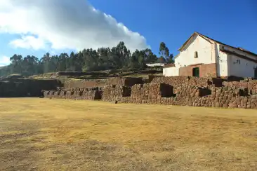
The main square of the city is
famous for its enormous Inca wall, with ten of the largest trapezoidal
niches known among Inca structures.
It was probably the base wall of a
palace, perhaps that of Topa Inca, which once faced the plaza, located
where the church now stands. The church has a colonial fresco around the
portico. Inside it was once beautiful, completely painted, walls and
ceiling, with flowers and multicolored patterns. Centuries of neglect
nearly destroyed these works of art, but much restoration had been done
in recent years.